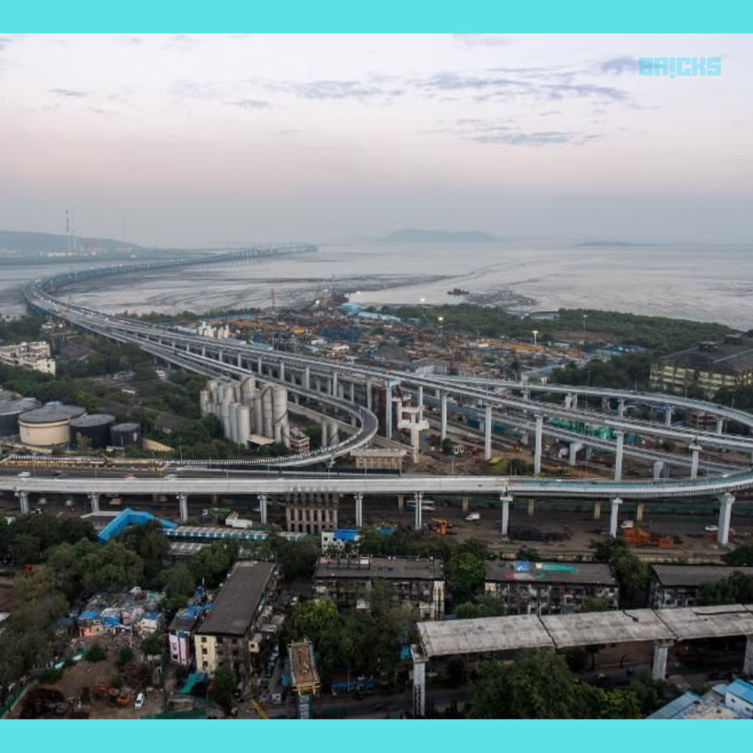
Mumbai Trans Harbour Link (Atal Bihari Vajpayee Sewari-Nhava Sheva Atal Setu) is India’s longest sea bridge, spanning 22 km. The sea link will connect Sewri in Mumbai to Chirle in Navi Mumbai. This blog is about Mumbai Trans Harbour Link| Atal Setu- Route Map, Toll Charges and More.
Latest News on Atal Setu (Mumbai Trans Harbour Link)
Atal Setu Opens to the Public on January 13, 2024; Witnesses Huge Traffic After the Inauguration
Jan. 16, 2024: PM Modi inaugurated Atal Setu on January 12, 2024, and it was made public on January 13, 2024. According to estimates released by the Mumbai Metropolitan Region Development Authority (MMRDA), on January 13 and 14, 2024, respectively, 24,000 and 55,000 cars crossed the sea bridge.
PM Modi Inaugurates Mumbai Trans Harbour Link (Atal Bihari Vajpayee Sewari-Nhava Sheva Atal Setu)
Jan 12, 2024:The longest sea bridge in India, the Mumbai Trans Harbour link (Atal Bihari Vajpayee Sewari-Nhava Sheva Atal Setu), was officially opened by Prime Minister Narendra Modi on January 12. Chief Minister Eknath Shinde was present for the ceremony. The time it takes to get from Mumbai’s Sewri to the Raigad district’s Nhava Sheva neighbourhood will be shortened by this bridge.
Key Features:-
- The Atal Bihari Vajpayee Sewari-Nhava Sheva Atal Setu is another name for the MTHL bridge.
- The bridge would set you back Rs 17,840 crore.
- MTHL is the abbreviation for the Mumbai-Trans Harbour connection.
- The bridge has six lanes and a length of 21.8 km.
- Interchanges are being built on National Highway 4B at Sewri, Shivaji Nagar, Jassi, and Chirle.
- National Highway 4B will be connected to the Mumbai-Pune Expressway.
- A 16.5-kilometer bridge spans the sea; the remaining portion is built on land.
- The Mumbai Trans Harbour Link toll for an automobile will be Rs 250 each way, with a round-trip fee of Rs 375.
- First, an open road tolling system should be implemented.
- Atal Setu is earthquake-resistant.

India’s longest sea bridge, the Mumbai Trans Harbour Link (MTHL), is 22 kilometers in total length. In addition, it is the world’s tenth-longest sea bridge. Another name for the sea bridge is the Sewri-Nhava Sheva Trans Harbour Link. IN this blog, Mumbai Trans Harbour Link| Atal Setu- Route Map, Toll Charges and More.
The primary goals are to lessen traffic jams and encourage local economic expansion. The sea bridge has a capacity of about 70,000 automobiles. Despite the satisfactory completion of slab construction and installation, the Mumbai Metropolitan Region Development Authority (MMRDA) has scheduled the start of traffic operations for November 2023. The decision to postpone the opening is probably motivated by a number of issues, including safety concerns and ensuring that all parts operate as intended.
MMRDA will be installing crash barriers, paving the deck, and erecting view cutters to increase visibility in the upcoming months. There are also plans to add lights and reflectors, place markings and signage, waterproof the engineering structure, set up open toll collection centers, and put security and surveillance equipment in place.
About Mumbai-Trans Harbour Link
The goal of the roughly three-decade-old Mumbai Trans Harbour Link is to drastically reduce travel times between Mumbai island and Navi Mumbai on the mainland, therefore revolutionizing transportation. With this cutting-edge infrastructure project, the trip will take only 20 minutes instead of two or three hours. Mumbai Trans Harbour Link| Atal Setu- Route Map, Toll Charges and More.
Not only will this magnificent feat of infrastructure enhance connectivity within Mumbai, but it will also bring several places closer to the city, such as Goa, Pune, and Nagpur. Additionally, the sea bridge will be the first to have an Open Road Tolling (ORT) system installed. The Mumbai Traffic Control Centre will use CCTV cameras to oversee traffic on the bridge, with a maximum speed limit of 100 mph.
Quick Facts: Mumbai-Trans Harbour Link
| Length | 22 kilometres |
| Name | Mumbai Trans Harbour Link and Sewri-Nhava Sheva Trans Harbour Link |
| Connection | Connects Mumbai to mainland |
| Location | It starts in Sewri and ends at Nhava Sheva |
| Travel Time Reduction | From existing 2-3 hours to approximately 20 minutes |
| Owned by | Mumbai Metropolitan Region Development Authority (MMRDA) |
| Estimated Cost | Over Rs 17,800 crore |
| Funding | 85% funding from the Japan International Cooperation Agency (JICA) |
| Project Model | EPC (Engineering, Procurement and Construction) |
| Width | 30.1 metres |
| Number of Lanes | Six |
| Deck Completion | Completed |
| Maximum Speed Limit | 100 km |
| Expected Traffic Operation | November 2023 |
Mumbai-Trans Harbour Link Route Map
Sewri in Mumbai and Chirle in Navi Mumbai will be connected by the 22-km Mumbai-Trans Harbour Sea Link. For commuters and cars commuting between these two locations, the link provides a direct route. The design also calls for a three-level interchange to connect the Eastern Expressway with the Sewri-Worli connection on the route that ends in Mumbai.
On the Navi Mumbai end, there will also be an interchange at Shivaji Nagar and Chirle. In addition, a noteworthy 4-kilometre steel span will be included to make it simpler for ships to dock at the Jawaharlal Nehru Port Trust (JNPT), which is located below. This specialized facility will ensure effective maritime operations.

What makes the Mumbai-Trans Harbour Link stand out?
The Mumbai-Trans Harbour Link project is an engineering marvel in itself. What makes it stand out is that it marks many firsts for India, such as:
- It is India’s longest seabridge.
- It is India’s first project that has an open road toll system.
- It was the first time that orthotropic steel deck technology was being used for construction in India.
Mumbai-Trans Harbour Link Package Details
The Mumbai Trans Harbour Link project has been divided into four distinct Packages are made up of one system package and three civil packages. For these packages, the MMRDA awarded the contracts for civil construction in November 2017. The contractors were assigned a 54-month timeframe in which to finish their responsibilities.
| Package | Details | Contractor |
| Package 1 | Sewri (in Mumbai) up to marker 10.38 km (10.38 km); inter-tidal and marine construction | Larsen and Toubro, IHI Corporation JV |
| Package 2 | Marker 10.38 km up to step 18.187 km (7.807 km); marine construction | Daewoo E&C – Tata Projects Limited JV |
| Package 3 | 18.187 km to NH-4B at Chirle, navi Mumbai (3.613 km); construction on land | Larsen and Toubro |
| Package 4 | Intelligent Transport Systems (ITS), including Toll and Transport Management Systems and Equipment Installation | STRABAG – EFKON India JV |

Mumbai Trans Harbour Link: Toll Rates
The Maharashtra government sets the Mumbai Trans Harbour Link’s (MTHL) toll prices. In the Raigad area, a single car ride between Sewri and Nhava Sheva can set you back about Rs 250. The bridge, also called the Atal Setu Bridge, will significantly cut down on travel time. At the moment, it takes two hours to go on the trip; when the MTHL link is available, it will take fifteen to twenty minutes. The Mumbai-Trans Harbour Link is among the priciest highways to drive on. For a driver, the cost is Rs 250 one-way and Rs 375 round-trip. The cost of the monthly pass for the same will be approximately Rs 12,500. By the next year, the government intends to update the charges. The Mumbai Metropolitan Region Development Authority (MMRDA) has informed us that the toll collection will be done until 2045.
Mumbai-Trans Harbour Link: Speed Limit
On the harbor link, the Mumbai Metropolitan Region Development Authority (MMRDA) has imposed a 100 kmph speed limit. Additionally, it is forbidden to use tractors, motorcyclists, and autorickshaws on the Mumbai-Trans Harbour Link.
Mumbai-Trans Harbour Sea Link: Real Estate Impact
The Mumbai Trans Harbour Link is expected to have a major effect on the real estate market in Mumbai and the neighboring districts. Among other mainland communities, the bridge would enhance connectivity between Navi Mumbai, Panvel, Karjat, Kalyan, Badlapur, Dombivli, Turbhe, Ghansoli, Airoli, Ulwe, Dronagiri, Ambernath, and Vasai.
Even though the current roads and bridges provide these communities with reasonable access to Mumbai, the completion of the Mumbai-Trans Harbour Link is expected to yield a significant improvement. Consequently, it is anticipated that real estate prices and economic activity in these areas will rise noticeably.
In an attempt to profit from the increase in demand for housing, a number of well-known real estate developers, including Godrej Properties, Arihant Group, and Marathon Group, have already begun building residential projects in the neighborhoods surrounding the MTHL project.
With this improved connectivity, inhabitants of these areas will also be able to commute more swiftly and conveniently, which will make it simpler for them to get to work, school, and other destinations. Additionally, more effective product and service transportation will be advantageous to enterprises.
Summary of the Mumbai-Trans Harbour Sea Link
The Mumbai Trans Harbour Sea Link, hailed as the longest sea bridge in India, has enormous potential for Mumbai and the surrounding territories. When the sea link is finished, it will not only cut down on travel time and traffic, but it will also create new commercial prospects. Additionally, it will make the flow of products and services easier and raise citizens’ standard of living in general.
With better connections and less traffic, it will enhance individuals’ daily lives, make commuting easier, and create new economic opportunities. The MTHL’s completion represents a significant turning point in the city’s infrastructure growth, one that has the power to enhance residents’ quality of life and communities’ prospects. The sea link, with its remarkable engineering and architecture, is a major infrastructure development achievement that will undoubtedly have a long-term effect on the future of the city.
Also Read: Plywood: Types, Advantages, Uses, & Price Range
Similar Topics: Mumbai Metro: Route, Map, Stations List, Name, Metro Lines, News


