Hyderabad metro route, also known as the Hyderabad Metro map, has been designed to cover a significant portion of the entire city, allowing users to travel around without trouble. India is a country that has increasing population growth, and the majority of people live in cities like Hyderabad. This has led to the demand for metro systems in cities has grown. The year 2003 was the first time that Hyderabad, as well as its sister city Secunderabad, joined forces to develop an initiative called the Multi-Modal Transport System (MMTS), which acts in the capacity of a commuter train connecting both cities. In this blog, we’ll discuss Hyderabad Metro Map, Route, Timings, Tickets, and Metro Lines.
However, the need for an urban metropolis has increased because of the system’s weaknesses and degradation over time. The Modal System’s second phase of system development, known as system planning, started in 2003. Hyderabad Metro was announced in 2003. Hyderabad Metro was described as an ambitious system that rapidly became a wide-ranging transport system. Although the metro was scheduled to be completed in 2015, test trains began operating in 2014—the first phase opening to the public on November 29, 2017.
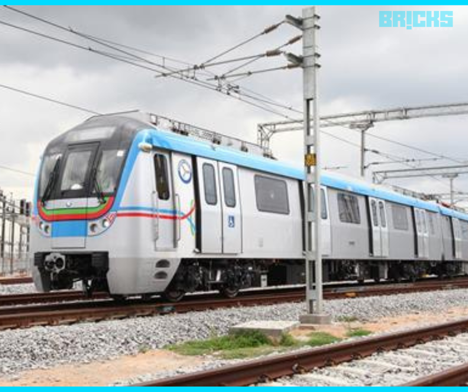
Hyderabad Metro is a city-wide Mass Rapid Transit System (MRTS) that operates through Hyderabad Hyderabad, the state’s capital city. Its Hyderabad Metro Rail (HMR) was first tested through the viaduct that runs along the 8km length of the line from Nagole to Mettuguda on July 14, 2014. It was completed in December 2017, and the 72-kilometer metro rail had three elevated corridors with standard gauge tracks with 64 stops, as well as three depots.
Hyderabad Metro Rail Lines
Hyderabad Metro Rail services operate throughout the city, including three interchange stations connecting three distinct lines.
- Red Line – Miyapur to LB Nagar via MG Bus Station, Nampally, and Ameerpet
- Green Line – JBS Parade Ground to MG Bus Station via Secunderabad
- Blue Line – Nagole to Raidurg via Secunderabad & Ameerpet
Let’s take a look at these two lines along the Hyderabad Metro route in more detail.
Red Line: The Hyderabad Metro’s Red Line travels from northwest to southeast and traverses the city’s center. It’s about 29 km long and includes 27 stations between Miyapur and LB Nagar. The train comprises three carriages traveling at speeds of 80 km/h and stops every 4-10 minutes.
Green Line: The Hyderabad Metro Green Line is operated by Hyderabad Metro Rail (HMR) and comprises 9 stops from all active Hyderabad Metro stations. Since its completion in 2019, the line has been fully operational for passenger use. It was originally planned in two phases, which include the 9.66-km route that runs from JBS towards MGBS and the 5.36-km route connecting MGBS towards Falaknuma.
Blue Line: The Blue Line is run through Hyderabad Metro Rail, comprised of 23 stops from Raidurg until Secunderabad East of the active Hyderabad Metro stations (HMR). Each train is equipped with three carriages and can travel at speeds up to 80 km/h. There is an average headway of 5-10 mins between trains.
Hyderabad Metro Map
The Hyderabad Metro is a rapid transport system that covers Hyderabad. The Hyderabad route map is explained in detail below:
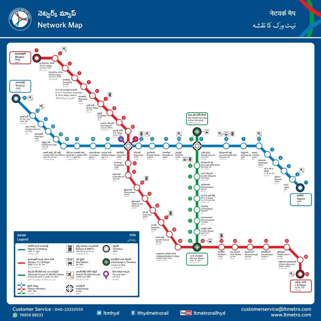
Hyderabad Metro Map: Red Line
Red Line Red Line is one of the metro rail lines that run through Hyderabad and is part of the Hyderabad Metro Rapid transport system. It is managed through the Hyderabad Metro Rail from all metro stations in Hyderabad.
The Red Line has 27 stations along this line, which is part of the Red Line. The line extends between Miyapur to LB Nagar and covers 29.21 kilometers. The two stations for interchange are situated on the Red Line of the Hyderabad Metro.
The stations that are part of the Red Line are listed below:
- Miyapur
- JNTU College
- KPHB Colony
- Kukatpally
- Balanagar
- Moosapet
- Bharatnagar
- Erragadda
- ESI Hospital
- SR Nagar
- Ameerpet
- Punjagutta
- Errum Manzil
- Khairatabad
- Lakdi Ka Pul
- Assembly
- Nampally
- Gandhi Bhavan
- Osmania Medical College
- MG Bus Station
- Malakpet
- New Market
- Musarambagh
- Dilsukhnagar
- Chaitanyapuri
- Victoria Memorial
- LB Nagar
Hyderabad Metro Map: Blue Line Route Map
The Blue Line is run by Hyderabad Metro Rail from all active metro stations in Hyderabad. The Blue Line is a line that runs starting from Nagole to Raidurg 27 kilometers and includes 23 stops. The two interchange stations are along the Blue Line of the Hyderabad Metro.
The stations along the Blue Line are listed below:
- Nagole
- Uppal
- Stadium
- NGRI
- Habsiguda
- Tarnaka
- Mettuguda
- Secunderabad East
- JBS Parade Ground
- Paradise
- Rasoolpura
- Prakash Nagar
- Begumpet
- Ameerpet
- Madhura Nagar
- Yousufguda
- Jubilee Hills Road No 5
- Jubilee Hills Check Post
- Peddamma Temple
- Madhapur
- Durgam Cheruvu
- Hitec City
- Raidurg
Landmarks Near Hyderabad Metro Blue Line
A few of the top attractions or landmarks near the Hyderabad Metro Blue line are given below:-
| Landmark | Metro Station | Distance from metro station |
| Inorbit Mall | HITEC City | 2.6 kms |
| Shilparamam | HITEC City | 0.6 kms |
| Durgam Cheruvu | Madhapur | 1.7 kms |
| GVK One Mall | Ameerpet | 2.4 kms |
| Sanjeevaiah Park | Rasoolpura | 2.5 kms |
| Butterfly Garden | Rasoolpura | 2.5 kms |
| Pedda Cheruvu | NGRI | 2.8 kms |
| Rajiv Gandhi International Stadium | Stadium | 0.7 kms |
Hyderabad Metro Map: Green Line Route Map
The Green Line is a line that extends starting from JBS Parade Ground to MG Bus Station, is an entire distance of 16.6 kilometers, and includes 15 stations. It is a public-private partnership that the Hyderabad Metro Red Line finances. Two interchange stations are on Hyderabad Metro’s Green Line.
The stations along the Green Line are listed below:
- JBS Parade Ground
- Secunderabad West
- Gandhi Hospital
- Musheerabad
- RTC Cross Roads
- Chikkadpally
- Narayanguda
- Sultan Bazaar
- MG Bus Station
Hyderabad Metro Lines (Interchange Stations)
There are three interchange stations on the Hyderabad Metro map/route that are as follows:
- Ameerpet Metro Train Interchange Station: This interchange station would assist the passengers traveling on Red Line and Blue Line.
- Parade Grounds Metro Train Interchange Station: This interchange station would assist the passengers in transitioning between Green Line and Blue.
- MGBS Metro Train Interchange Station: This Interchange Station is for the passengers that travel on Red Line and Green Line.
Hyderabad Metro Fare
Fares for the Hyderabad Metro Hyderabad Metro route are determined according to the distance traveled and the kind of ticket bought.
For tokens (for only one journey) or smart cards (for multiple trips) can be purchased for just INR 20. They also offer discounts during the season (a maximum of 10 percent ). Customers can recharge their smart card at a rate of INR 50. Additionally, the credit of INR 10 should be maintained within the card.
- The minimum fare for those on the Red Line, Blue Line, and Green Line is INR 10.
- The maximum price for both the Red Line and Blue Line is INR 60. In contrast, the full cost for the Green Line is INR 35.
- If you begin your journey at Miyapur via the Red Line, it will take 15 minutes to get to JNTU College, INR 40 to get to ES Hospital Metro Station, and INR 60 to get to L.B. Nagar.
- If you get on the train from Nagole along the Blue Line, you can get to Metro Stations at the Stadium Metro Station for INR 15, Ameerpet Metro Station for INR 45, and Raidurg Metro Station for INR 60.
- If you get the subway starting from JBS Parade Ground Metro Station on the Green Line, you can travel to Secunderabad West for INR 10, RTC Cross Roads Metro Station at INR 15, and MG Bus Station 3 for INR 35.
Hyderabad Metro Timings
- The Hyderabad Metro Rail is operational from 6 am to 11:15 pm.
- When the first train leaves the station at 6:30 am, The final train leaves at 10:15 am and will arrive at the station’s final destination at 11:15 pm.
- In peak times during peak hours, you can get an hourly metro ride. In non-peak times you can ride trains every eight minutes.
- Red Line: The Red Line metro train takes 52 minutes to complete the 28-km distance from Miyapur to L.B. Nagar.
- Blue Line: The Blue Line takes 53 minutes to complete the 26.8-km route from Nagole to Raidurg.
- The Green Line takes 16 minutes to complete the 7.7-km route between JBS Parade Ground and Sultan Bazar.
- If you depart at Miyapur along the Red Line, it will take three minutes to get to JNTU College, 19 minutes to get to ES Hospital Metro Station, and INR 52 mins to reach L.B. Nagar.
- If you take the train from Nagole to Nagole on the Blue Line, you can get to Nagole’s Stadium Metro Station in 4 minutes, Ameerpet Metro Station in 29 minutes, and Raidurg Metro Station in 53 minutes.
- If you get a Metro starting from JBS Parade Ground Metro Station on the Green Line, you can get to Secunderabad West in 2 minutes, RTC Cross Roads Metro Station in just 1 minute, and Sultan Bazaar in 16 minutes.
Hyderabad Metro Station Facilities
- It is believed that the Hyderabad Metro is the first in the nation to provide “in-flight” entertainment for commuters on trains who can watch and download videos, games, and music on the go by pressing the button. There are also charging stations in the metro. The metro has user-friendly stations equipped with lifts, stairwells, and facilities for disabled passengers.
- The station has automated ticket vending machines and a fare collection method, and a convenient way to access. Telephones and toilets are some of the most important amenities at stations.
Hyderabad Metro Tickets
Contactless Smart Cards (CSC) and Contactless Smart Tokens (CST) can be used to board a metro system in Hyderabad.
Non-contact tokens are a pre-paid fare medium utilized to pay for tickets at Hyderabad stations for travel. You can purchase tokens for one-way travel or buy a token to pay to return the trip. It’s a good alternative for those who don’t frequent their rides.
Contactless Smart Cards serve as stored value cards which can be non-monetary (e-Purse) and non-monetary (Pass), or a mix of both, and have a range of options to attract people who use them regularly and frequently. A value of money equal to the number of fares between two stations can be withdrawn from the value stored when you exit the Gate.
Hyderabad Metro Automatic Fare Collection
Hyderabad Metro Rail ticketing solution is an innovative Automated Fare Collection System based on No Contact Fare Media Technology.
Automated gates for entry and exit and fences separate the zones of paid and unpaid metro stations. This is done for only persons with valid tickets can access the system. You can check the key both at exit and entry points.
Latest News On Hyderabad Metro Rail
On the morning of Independence Day, Hyderabad Metro was shut down for 52 seconds from 11:30 Am to perform the National Anthem. Trains were stopped in all metro stations. This event was to mark two weeks of celebrations for Swatantra Bharatha Vajrotsavalu to mark the 75th Independence Day.
L&T Metro Rail Hyderabad is launching the world’s first Super Saver Metro Festive Card that will allow Hyderabad residents to move around more conveniently and at a lower cost beginning this Ugadi. The new Super Saver Metro Holiday Card costs INR 50 for 100 eligible holidays. The card comes with a value for a top-up of INR 60. The card permits users to travel between three metro stations, 57 of which are lines along the Hyderabad metro route.
Also Read: Lucknow Metro – Route, Lines, Fare, Timings, and Latest News
Similar Topics: Indore Metro: Route, Map, Schedule, Fare, and Latest News


